

Community Readiness and Resilience Toolkit
Step 3: Assess vulnerability and understand risks
step 3: Assess Vulnerability and Understand Risks
Step 1
Get Started
Step 2
Identify Concerns and Gather Information
Step 3
Assess Vulnerability and Understand Risks
Step 4
Develop Resilience Strategies
Step 5
Take Action
Step 6
Monitor, Adjust, and Maintain Your Plan
Step 3
In this step, you will determine what sectors, communities, resources, ecosystems, and community assets are most vulnerable to ongoing community stressors, projected changes to climate and extreme weather events, man-made and natural hazards, and other current and future shocks.
Guiding Questions
- What current shocks or stresses already impact your community?
- What future changes could exacerbate stressors on your community?
- Is your community already able to accommodate or respond to current changes? What about projected changes?
- Are there barriers to your community’s ability to accommodate future change (such as climate change, demographic shifts...etc.)?
- What is the likelihood of those impacts occurring? How often will they occur in the future?
- Who or what will be affected if a given impact occurs? How many people? What types of infrastructure? What natural systems? These consequences might include impacts to operations or ecological, social, cultural, and legal impacts.
Checklist for Step 3
- Activity 1: Select Your Approach to Assess Your Community’s Vulnerabilities and Risks
- Activity 2: Define Your Communities Vulnerability and Risk to Future Shocks and Stressors
- Activity 3: Summarize Your Findings
Step 3, Activity 1: Select your approach to assess your vulnerabilities
There are many ways to assess your community’s vulnerabilities and risks to current and future changes. In this activity, you will determine the depth, breadth, and approach of the vulnerability and risk assessment process. Depending on the scope of your project (see Step 1) you may work with your core team and decide to focus on specific sectors or specific hazards.
Tips
- It is important to communicate the rationale and findings of your work to the broader community effectively. Deciding on a clear definition of vulnerability and the concepts that define it is important both for conducting the analysis itself as well as ensuring its results are understandable.
- Customize your vulnerability assessment to meet your needs. This can be done by sector (e.g., transportation infrastructure) or by hazard (e.g., wildfire, drought, etc.). Specific types of infrastructure or other technology may require a more technical approach due to the complexity of the systems in question. Depending on the specific sectors important to your community, you may also choose a more focused approach that highlights specific key livelihoods, populations, social equity concerns, or infrastructure systems. Choose an approach that works best for your community.
- Consider the intersectionalities of shocks and stressors in your community. Many of the things we care about are connected to other things we care about. Likewise, many types of hazards can have secondary effects that lead to other hazard occurrences or amplify background stressors over the long term. For example, wildfires can threaten lives and destroy homes in the immediate term, but also lead to increased erosion in burn areas and increase flood risks. The 2020 Colorado Resilience Framework has the concept of “One Thing Leads to Another…” to highlight how different shocks and stressors can add up over time to create new, more complex challenges.
Why?
Depending on your specific project or need, the scope of your vulnerability assessment and its importance to a given project’s success will vary. Scenario planning exercises will help you to explore and understand, at a general level, the potential shocks, stressors, and cascading impacts that your community could experience. Yet, more detailed planning efforts (e.g., pre-disaster planning, local hazard mitigation planning, or climate adaptation planning) may require a deeper analysis like a Vulnerability Assessment and/or a Risk Assessment. In addition, projects focused on specific types of infrastructure or other technology may require a more technical approach due to the complexity of the systems in question. Communicating clearly about how, why, and for what purposes vulnerability assessments are being conducted can help to ensure more effective community buy-in and an effective translation into action.
When?
This activity should be conducted prior to developing resilience strategies and be adjusted as necessary as this process progresses. Depending on the size and scope of your need, it can be completed in the timeframe of a few weeks to a few months.
How does my community do this?
Contact the CRO. The Colorado Resiliency Office supports Colorado communities to understand and define their vulnerabilities and risks to current and future shocks and stressors through a variety of scenario planning exercises. If you would like assistance in your scenario planning work, be sure to connect with your DOLA regional manager.
Define the scope for understanding and defining your community’s shocks and stressors. Scenario planning exercises may help you explore and understand, at a general level, the potential shocks, stressors, and cascading impacts that your community could experience. Yet, more detailed planning efforts (e.g., pre-disaster planning or climate adaptation planning) may require a deeper analysis like a Vulnerability Assessment and/or a Risk Assessment (for more information, reference the Climate Ready Communities Guide to Building Climate Resilience (pages 55-82). The CRO has created four templates to support your work in the workbook: 1) a shocks and stressors template, 2) assess vulnerability template, 3) assess risk template, and 4) risk matrix template. It is here that you set boundaries on the specific project - or expand on previous work - and identify what you want to achieve in the process. A few questions to consider:
What scale are you examining? The whole region, the town, an industry within the town?
What range of hazards will you consider in-depth?
Will you be examining all community assets (e.g., public health), or focusing on a specific subset?
Choose your method for understanding and defining your community’s shocks and stressors. Choose an approach that both ensures trust within your community and is feasible given project resources. If possible, it is best to utilize multiple methods for completing your vulnerability assessment. Methods include scenario planning exercises at a general level. Or, you can do this at a deeper level by completing an in-depth vulnerability and risk assessment (for more information, reference the Climate Ready Communities Guide to Building Climate Resilience Step 3 (pages 55-82). Commonly used methods include indicators-based analyses, like geospatial analysis, economic analyses, and census data socio-demographic profiles. These provide general descriptors of a location and the people and systems within it. Alternatively, qualitative, social science-based approaches can capture local network characteristics, tipping points, and other complexities - such as how local businesses are affected by nearby wildfires when they rely upon tourism.

Image Description: Flow chart depicting the impacts of drought. To the left is a box with drought that connects to three different flow paths. At the top it shows Drought leads to Dry Forests and Prairie, which leads to Wildfire, which leads to Bare Slopes, which connects into Flash Floods. The second flow path shows Groundwater Withdrawals, which leads to Subsidence, which leads to Compacted Soils and again ends in Flash Floods. The third flow path is Economic Hardship, which all paths ultimately lead to. Chart also shows that Wildfire is compounded by Hot Weather and Flash Floods and Flood Damage are compounded by Heavy Rains.
Community Call Out: Cortez, CO
In 2018 the City of Cortez worked with program coordinators at the Western Water Assessment to hold a multi-day workshop on assessing community vulnerabilities and adaptation options. Bringing together city staff, members of the planning and city councils, and scientists from the Western Water Assessment, it focused on observed historical and future climate conditions, risk perceptions at the local level, and scenario development in the event of critical threats, such as a repeat of recent extreme droughts. It identified many specific local chains of events and consequences for several specific risk factors, allowing planners to play out how they can respond at different stages of a risk process. As detailed in their workshop report, this process allowed them to both engage with broad drivers of vulnerability and to ground adaptation planning options in a knowledge base that reached across the city’s numerous municipal departments and governmental agencies.
Step 3, Activity 2: Define your Vulnerabilities and risks to future shocks and stressors
In this activity, you will define your community’s vulnerability (based on current and projected exposure, sensitivity, and adaptive capacity) and the probability and potential magnitude of a hazard or stressor on your community.
Tips
- Build on the work already happening in your community and region. You don’t have to reinvent the wheel! One asset for networking across government agencies and planning offices can be found through the Colorado Resiliency Office’s Peer Exchange program, which links local planners virtually.
- Integrate local knowledge. As you work on assessing vulnerability, local knowledge can be both a critical source of information as well as a key link to community support for your findings. Community feedback can also help reality check findings that may be based on generalized assumptions that do not apply in certain areas of the state.
- Think about “thresholds” when assessing vulnerability. Many systems operate well under a certain amount of stress and can withstand a certain degree of shock. However, once either stresses or shocks pass a certain intensity, or certain key aspects of the system are compromised, rapid failure of other parts of the system may follow. Try to identify when critical assets might be overwhelmed and what the consequences of that might mean for the community and other valued places, things, systems, and services.
Why?
To develop resilience strategies, it is essential to identify and assess the community’s vulnerability to current and future shocks and stressors as well as the likelihood and extent that they will impact your community.
When?
This will likely take between 1-3 months but will ultimately depend on the scope of your assessment and your approach to the assessment.
How does my community do this?
See what's out there. Assessing your vulnerabilities and your risks can be complex. If you require a deeper analysis, you can use tools like the US Climate Resilience Toolkit, the ICLEI Guide to Building Climate Resilience (pages 38-43), the Climate Ready Communities Guide to Building Climate Resilience (pages 55-82), or the FEMA Local Hazard Mitigation Planning Handbook (pages 5.1-5.20). You can also utilize the assess vulnerability template in the workbook.
Inventory key community assets. It is important to begin this process by conducting an inventory of assets that are important to your community. What things, places, infrastructure, neighborhoods, parks, or community characteristics are important to your community? Inventory these through broad community engagement, expert input, background research, and conversations and synthesis among the core project team.
Determine each asset’s exposure, sensitivity, adaptive capacity, and vulnerability to shocks and stressors. Once you have a list of assets, you will need to determine their exposure to shocks and stressors. Consider past, present, and potential future stressors - natural, climate change-related, social, demographic, economic, or otherwise – that may cause harm or create opportunities for your community. For a deep dive on the impacts of climate change on public health, learn more from the Colorado Health Institute’s Colorado’s Climate and Colorado’s Health Guide and Global Issue, Local Risk vulnerability index.
The relative vulnerability of key assets in your community depends on their exposure, sensitivity, and adaptive capacity. As you analyze and evaluate each of these characteristics of the assets and systems you will begin to get a clearer picture of your community’s overall vulnerability. These relative vulnerability rankings will provide you with the foundation to begin making choices about different resilience initiatives. Determining the relative vulnerability highlights which specific assets or parts of the community are most in need of immediate action to deal with future changes and can provide a more contextual description of how individual assets experience particular vulnerabilities. See the assess risk and risk matrix templates in the workbook.
Characterize your community’s risk. To characterize your community’s risk, you will need to consider the potential magnitude and probability of a potential hazard. This includes understanding how frequently an event has occurred in the past, and how climate change (or another driver) may change the frequency and severity of a hazard over time.
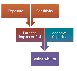
Image Description: Flow Chart determining vulnerability. At top of chart, Exposure and Sensitivity lead to Potential Impact or Risk and Adaptive Capacity which ultimately flow into Vulnerability.
Community Call Out: Gunnison and Craig
In 2015, researchers working for the Colorado division of the Bureau of Land Management conducted a climate change vulnerability assessment focused on public land users and public land management. It took a three-tiered approach to data gathering that included: a systematic review of existing policies and practices within the agency’s planning resources that may change with response to climate stressors; a review of census data and public land use data using geospatial mapping and statistical analysis; and, in-depth case studies centered on two field offices located in Craig and Gunnison. Through numerous interviews, researchers identified some important dimensions of both general climate and weather vulnerability among public land-dependent communities. These results included specific aspects of land management that could exacerbate or ameliorate these risks, such as flexibility with cattle movement during drought. When compared with land use data, employment, and permitting statistics, it was possible to use insights from these case studies to select variables that highlighted parts of the state with elevated levels of dependence upon public land resources through direct and indirect economic and cultural links.
Step 3, Activity 3: Summarize your findings
In this activity, you will develop a draft report and summary of the information compiled in this step to share with your technical working group, leadership, and the broader community.
Tips
- For additional tips on conducting an effective Rapid Needs Assessment, Initial Damage Assessment (IDA), Joint Preliminary Damage Assessment (Joint PDA), and Recovery Assessment see the Additional Guidance section below.
Why?
Good planning requires good communication. Compiling your vulnerability and risk results into a format that can be shared and effectively communicated to the public is essential to helping you reach your resilience goals.
When?
This activity can take 4-6 weeks to complete. You can likely shorten this timeframe by planning early how you will summarize your findings and conduct this activity in parallel with the previous activities.
How does my community do this?
Prepare a draft report for review. The format of the specific products you develop will vary depending upon the scope of your vulnerability analysis and decisions made by your project team; it can also depend on the particular characteristics and needs of your community. This information is often summarized in a report.
Disseminate and review with the core project team, leaders, and community partners. Incorporate feedback from internal team members and collaborators and finalize your assessment. To view examples of vulnerability assessments, view the US Climate Resilience Toolkit.
Share for public comment. Consider sharing the vulnerability assessment report broadly. Receiving community feedback, and making adjustments as necessary can not only strengthen the report but help solidify the acceptance of the results and build support for actions to enhance resilience.
Finalize your vulnerability assessment and share widely. Several standard approaches for sharing findings include:
Compiling an official, detailed report of findings.
Creating a short, 2-5 page executive summary-style document meant for high level conversations and broader dissemination.
Working with local reporters and community members to share reports and results.
Creating webinars, educational videos, and other multimedia approaches to presenting vulnerability assessment findings.
Disseminating information through traditional and social media platforms.
Sharing copies of the assessment at public events.
Additional Guidance for Step 3
Click on the question to expand the answer.
+ My community knows we are vulnerable to a specific hazard that occurred recently. Do we still need to do this?
Yes. Recent events may have the ability to create a sense that everyone is aware of the risks associated with it, but part of planning over the long term is ensuring that this kind of hard-won knowledge doesn’t fade over time. Recent events can make excellent case studies in understanding your community’s vulnerabilities and can point out exact places where changes need to be made to avoid or minimize impacts in the future. At the same time, the vulnerability assessment process can help you to understand the full range of risks your community might face, as well as those that are top of mind due to recent occurrences.
+ People in my community are concerned that this process might diminish their property values or paint their neighborhood in a bad light. How can our project team address this?
Designating properties or neighborhoods as high risk or high vulnerability can often take on a negative connotation, and people may react defensively. For this reason, it is critical that the project team highlight, throughout the vulnerability assessment process, the visions and goals for resiliency that the community hopes to achieve. This is another reason that active engagement and outreach are important, as it ensures that those likely to be the most critical of a vulnerability assessment process have the opportunity to understand its value, take ownership of its process, and feel benefitted by its outcomes.
+ My community is heavily reliant upon recreation in the area outside of the direct control of our government agency. How do we factor this into our assessment process?
Many areas in Colorado have economies that rely heavily on tourism and businesses outside their jurisdiction. This can make planning processes tricky, as some of the most important assets your community relies upon are outside of your control - and may even be quite far away, geographically. In these cases, attempt to coordinate with agents from the managing agency that oversees the resources in question. Depending on your case, this may include private ski area operators, public land agencies (the USDA Forest Service, the National Parks Service, the Bureau of Land Management, or Colorado Parks and Wildlife, for one example). This can provide both access to valuable information about these assets as well as help to coordinate across plans that have the potential to impact one another.
+ My community is heavily reliant upon privately-owned agricultural operations outside of our jurisdictional boundary. How do we factor this into our assessment process?
Agricultural operations in Colorado are one of the key places where climate and weather can have their most severe impacts. These can, in turn, affect the well-being of nearby towns and communities that often have little to no say on how those farms operate and manage risks. One potential partner that can help facilitate this gap and lead to better understanding is the Colorado State Extension Service, which works with farmers and ranchers across the state to bring scientific information and educational resources to agricultural operators. Similarly, the Northern Great Plains USDA Climate Hub can also be a valuable resource for information and skills needed to bring farmers and ranchers into the community planning process.